Nestled within the majestic vistas of Colorado’s Rocky Mountain National Park, the Blue Lakes Trail stands as a testament to nature’s unparalleled beauty. This trail, a jewel among the park’s diverse hiking options, offers adventurers an unforgettable journey through stunning landscapes and breathtaking panoramas.
As you embark on this scenic trek, you’ll find yourself mesmerised by the vibrant hues of wildflowers in summer, the serene beauty of crystal-clear alpine lakes, and the awe-inspiring sights from towering peaks.
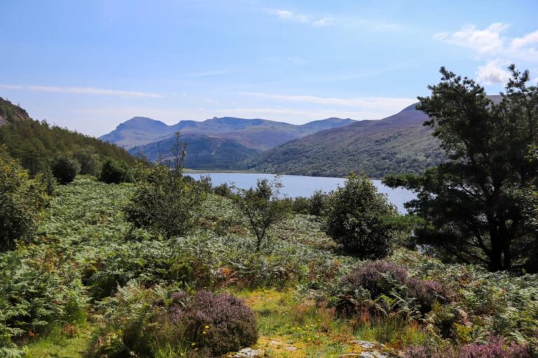
Explore The Rocky Mountains
The Rocky Mountains are definitely worth an extended trip for outdoor enthusiasts. I love this area and I’m so fortunate to call this state my home.
For those seeking to venture a bit further, the journey towards Monarch Mountain reveals another facet of Colorado’s spectacular natural diversity. Monarch Mountain is positioned between the heart of Rocky Mountain National Park and the broader expanse of the Colorado wilderness; offering trails that weave through dense forests and open into expansive meadows, offering a different yet equally magnificent perspective on the Rockies’ grandeur.
The Bear Lake Loop is another worth considering, with its gentle path, provides panoramic views of the surrounding mountains and dense, evergreen forests, making it an excellent choice for families and those desiring a more relaxed hike. I could honestly go on with the sheer amount of choice in this beautiful state from the Sky Pond Trail to the paths enveloping Monarch Mountain, promises its own unique adventure, inviting hikers of all levels to discover the profound beauty and tranquillity of this extraordinary wilderness.
Where Is Blue Lake Trails
The trail is located in the Mount Sneffels Wilderness of Uncompahgre National Forest. This falls in the Southwest region of Colorado between Telluride, CO and Ouray, CO. It’s an extremely beautiful part of the state. Ouray is known as the Switzerland of America, as it is surrounded by mountain peaks. Telluride was once a mining town and is now famous for its skiing, beautiful scenery and waterfalls.
Getting to Blue Lakes
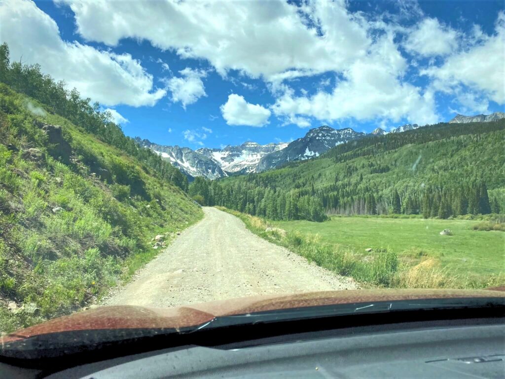
The trailhead is located off of Hwy 62 going west from Ridgeway, CO. You’ll turn on County Road 7 and drive for 9 miles (14.5km). This is a bumpy dirt road so a vehicle with AWD is recommended, although you can make it with 2WD. From Ouray to the trailhead it will take 45-50 minutes driving. From Telluride, it is about 90 minutes to the trailhead. The views are amazing on the drive in so it’s a nice warm-up to the hike.
If you are planning to visit any of the United States and explore more wonderful trails and national parks, don’t forget to get your park pass and do your research.
Blue Lakes Trail Overview
Location: Mount Sneffels Wilderness
Distance: 6.3 – 11.0 miles / 10.1km – 17.7km (round trip)
Elevation: 9,350ft – 13,000ft / 2850m – 3962m
Elevation Gain: 1,590ft – 3,65ft / 484m – 1113m
Difficulty: Moderate-strenuous
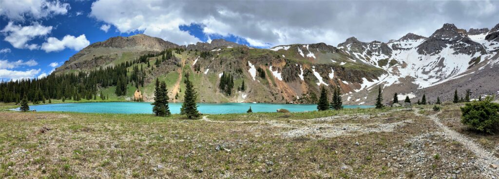
The Blue Lakes Trail is one of the most sought after hikes in the San Juan Mountain Range of Colorado. The trail sits along 3 turquoise blue alpine lakes, which are surrounded by rugged mountain peaks reaching over 13,000 ft (3962.4m). It’s truly a sight to see.
The Trails
You can make this hike as difficult as you would like. There are three markers to which you can hike to – the Lower Blue Lakes (6.3 miles roundtrip), the Upper Blue Lakes (8.2 miles round trip), or to Blue Lake Pass (11 miles round trip).
- Lower Blue Lakes
Distance: 6.3 miles round trip (10.1km)
Difficulty: Moderate
Elevation Gain: 1,590ft (484.6m)
Time: 4 hours
- Upper Blue Lakes
Distance: 8.2 miles round trip (13.2km)
Difficulty: Strenuous
Elevation Gain: 2,400ft (731.5m)
Time: 5-6 hours
- Blue Lakes Pass
Distance: 11.0 miles round trip (17.7km)
Difficulty: Strenuous
Elevation Gain: 3,650ft (1,112.5m)
Time: 6+ hours
The area surrounding these lakes are filled with wildflowers in the summer. Once the snow has melted, hikers can spot columbine (Colorado’s state flower), Indian paintbrush, pink moss campion, purple larkspur, lupine, red queen’s crown, and alpine avens. It is best to view these wildflowers from mid-July to mid-August.
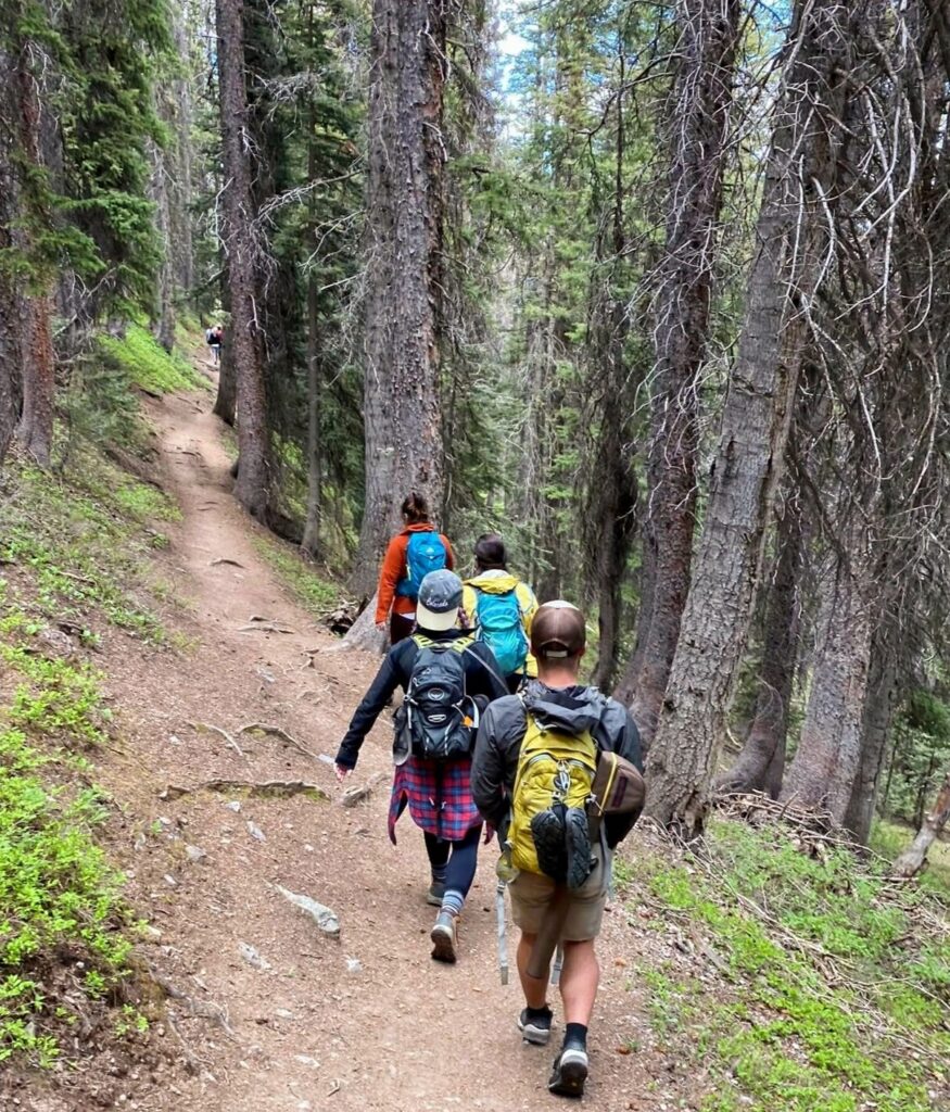
The trail begins at around 9,350ft (2,850m) elevation. You begin on a moderate grade of switchbacks in a forested area of pine and Engelmann spruce trees. The path continues up the valley between Mount Sneffels and Wolcott Mountain. At 1.5 miles, you cross a stream then a third of a mile to the lower falls you’ll see a waterfall to your left. You’ll reach a signed junction point with a short trail leading straight to the Lower Blue Lake or to the left to the Upper Blue Lakes.
The turquoise blue Lower Blue Lake sits at 10,980ft (3,346m) elevation and is the largest of the three lakes. Mount Sneffels has a commanding view to the east side of the lake with its steep rugged slopes going down towards the lake.
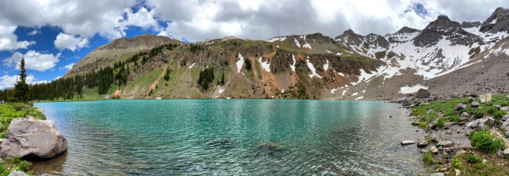
Mount Sneffels is an impressive 14,150ft (4,313m) high and is the third highest peak in the San Juan Mountains of southwestern Colorado. The name came from Frederic Endlich during an expedition in 1874. He thought the mountain looked like Mount Snaefell in Jule Verne’s “Journey to the Center of the Earth”.
Campsites are located in the lower lake area, as many people use this location to base camp before they begin their climb of Mount Sneffels. Campsites can also be found at the trail head.
What Makes These Lakes So Blue?
These lakes have a vibrant blue color to them, not because of the reflection of the sky, but because of the glacial flour that sits in the water (similar to that seen in the Canadian Rockies or Swiss Alps). When the surrounding glaciers melt in the warmer months, these basins fill with water. The glacier runoff has glacial flour in it, which is finely ground rock. This sediment is so light that it does not sink and stays suspended in the water. The particles then distort the sunlight hitting the lake into a bluish-green hue that is visible to us.
From the lower lake, the trail gets much steeper to the upper lake. You will ascend 500ft (152.4m) in just over a half a mile to reach the middle lake at 11,500ft (3,505m) elevation.
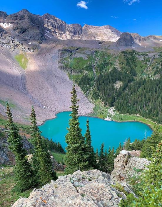
A quarter-mile from there is the upper lake at 11,720ft (3,572m) elevation. The upper lakes provide a scenic panoramic view of the Lower Blue Lake below, Mount Sneffels, Gilpin Peak and Dallas Peak.
The trail continues to the Blue lakes Pass at 13,000ft (3,962.4m) elevation. This is a steep climb with drop-offs along a narrow path. From the top, you can soak in the epic view of all three blue lakes below.
About the Laura:
Laura is a Colorado adventurer and enjoyed being active outdoors. You can typically find her hiking or cycling up a mountain. She runs the blog All The Colorado Things which focuses on adventure and travel in Colorado. You can also follow her adventures on Instagram.
#adventuretravel #hiking #colorado #unitedstates #bluelake #trekking #camping #mountains #adventure